Planning
Glossary
Official documents identifying the owner, address and identification number (parcel identification description/PID) of the property where the proposed work is to be carried out. These documents make it possible to verify that you are indeed the owner or that you have the owner's authorization to carry out the work.
Designates all work designed to increase floor space or the volume of buildings or other structures.
Whenever a provincial department's permission or authorization is required, the Community Planning Act stipulates that a permit can only be issued after the development officer has verified that the project meets the requirements of all other government-prescribed regulations (sec. 81). This means that the Department of Agriculture, Aquaculture and Fisheries, the Department of Environment and Local Government, the Department of Transportation and Infrastructure, the Department of Natural Resources and other departments may be required to provide authorization before a building or development permit may be issued.
Document issued by the Department of Health inspector certifying that the plans for your on-site septic system (as drawn up by the installer) meet provincial standards. For further information, please contact the Department of Health.
Designates a building or structure that is detached from the primary building or structure and whose use is ordinarily accessory in nature and subordinate to the use of the primary building or structure. It is not used to provide shelter to humans or animals and is located on the same parcel of land as the primary building or structure (e.g. shed, garage, gazebo, stoop, patio, enclosure, swimming pool, embankment, excavated soil).
Designates a building in which the principal purpose of the lot is carried out (e.g. a single-family home would be the primary building on a residential lot).
Document issued by the Town of Caraquet's heritage preservation committee or heritage officer under Town of Caraquet By-Law No. 185 concerning the preservation of municipal heritage and related amendments. This permit is required for:
- Development in the business improvement zone.
- Development involving a building or parcel of land appearing in the list of historic buildings and sites.
- Any commercial use within the entire conservation area.
- Signage along Saint-Pierre Blvd. and Rue du Portage.
For further information, please contact the Town of Caraquet.
Document issued by the Department of Transportation and Infrastructure under the Provincial Setback Regulation. This document determines the distance to be maintained between a project and the limit of a road or street within a local service district (LSD) only. A certificate establishing the setback is required for all requests to perform work located at least 30 m (100 ft.) from the road/street limit. For further information, please contact the Department of Transportation and Infrastructure.
Designates a single-family dwelling used to house an individual or family for up to six (6) months of the year. In general, in a municipality, a mobile home or trailer is not considered a cottage.
E.g. adding a suite to a single-family dwelling or converting a former commercial space into a single-family home.
Designates a structure (other than a dividing wall) used to obstruct passage or enclose a space.
Diagram showing the front view of the accessory building and indicating the building dimensions and openings (doors). This diagram may be used to verify whether a project is in compliance with the zoning by-law, for example.
Designates an earthmoving operation involving the removal of earth for grading (levelling) purposes. Also designates any development in which the ground is lowered by at least one metre from the original level.
Designates the demolition of an existing building or structure.
Designates any type of advertising, poster, notice, panel, form, means or device, whether constructed, pasted or painted, in addition to any form, means or device suited or adaptable to that purpose, whether used for that purpose at the moment in question or not.
Information document designed to help applicants define their proposed activity. This document is necessary to have a clear understanding of the proposed use and for its categorization by the development officer. This information sheet is also used to clarify the impacts of the activity on the immediate environment and any potential conflicts between users of the territory.
Designates an attached or detached building used to store motor vehicles designed for the personal use of the owner or occupants of the primary building. A garage is considered an accessory building if it is detached from the primary building.
Designates a small decorative pavilion usually open on all sides and not used for storage purposes. It is considered an accessory structure if detached.
Designates a dwelling with two units.
Designates a home with more than two dwelling units.
Designates a dwelling consisting of only one unit.
E.g. prefabricated home or relocating an existing building to another parcel of land.
Document issued by the Office of the Fire Marshal (a division of New Brunswick's Department of Public Safety) under the Fire Prevention Act. In accordance with Bulletin 2003-02, a letter is required for the following projects:
- Buildings and tents used for gatherings of at least 50 people for the purposes of meetings, entertainment, instruction, religious ceremonies, recreation, training, examination or purchasing items. This includes athletic centres, churches, nightclubs, restaurants, schools, shopping centres, retail stores, cinemas, etc.
- Daycare centres.
- Dwelling places and condominiums with more than three self-contained units above street level, motels, hotels, inns, tourist guesthouses, hospitals, nursing homes, special nursing homes with more than four residents, prisons, student residences, boarding houses, etc.
Projects for which a letter is not required: - Federal buildings on federal land.
- Industrial buildings such as pulp and paper mills, refineries, manufacturing plants, warehouses, cold storage plants, processing plants, etc.
- Service stations and parking garages.
- Linear housing such as terraced or row houses (townhouses).
- Apartment buildings and condominiums with fewer than three self-contained units above street level, e.g. a building with four dwelling units, two of which are located at street level and two on the first floor.
- Retail outlets and businesses such as convenience stores that can accommodate up to 50 people at the same time.
For further information, please contact the Office of the Fire Marshal, Department of Public Safety.
Designates a home that is habitable year-round and designed to be used with or without a permanent foundation for the dwelling unit, measuring at least 6 metres in width for its entire length (not including stairs and balconies). It may or may not be fitted with towing equipment but can be transported using a platform trailer from the construction site without significant modifications to the structure. The exterior walls must be made out of building wood measuring 5.08 cm x 15.24 cm in accordance with the national building code in effect. A mobile home is not considered a cottage and cannot be used to enlarge any type of dwelling.
Designates the acronym of the parcel identification description assigned to most properties in New Brunswick by Service New Brunswick.
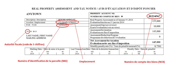
(See the sample notice of assessment and property tax assessment below.)
E.g. home, garage, shed, gazebo, etc.
Designates all required structures serving as a base for construction.
Upgrading from a fuse panel to a breaker panel. Modifying the intensity of the electrical current or completely replacing a panel.
Designates an exterior surface covered with planks or paving and usually attached to a building. The dimensions and location are subject to local regulations.
Permit issued by the municipal government certifying that the proposed project can be connected to the water or wastewater utilities. For further information, please contact your municipality.
Document issued by the Department of Environment and Local Government under the Clean Water Act and the Watercourse and Wetland Alteration Regulation. This permit is required in the following cases:
- An alteration is made to a watercourse or a wetland; or
- A disturbance of the soil occurs less than 30 metres (100 ft.) from a watercourse or wetland.
For further information, please contact the Department of Environment and Local Government.
Designates an exterior staircase whose last step is level with the front door and is slightly above ground level.
Designates an exterior reservoir or structure created artificially (at least in part) and used on a seasonal basis. It is designed to hold water for the purposes of swimming, diving or other activities for personal, private or commercial use.
For all multi-family residential, commercial, institutional or industrial projects, the drafting of scale drawings by a registered architect with, as needed, a provincially registered engineer, is required. These are building plans with dimensions showing:
- The 4 elevations of the building or structure indicating the size, dimensions and list of materials to be used.
- The projected use of each room or floor space.
- Cross sections of walls, foundations, floor plans and details.
- Structural details of floors.
- Stairways (railings, headroom).
- Any other drawings requested by the building inspector.
Building plans with dimensions showing:
- The 4 elevations of the building or structure indicating the size, dimensions and list of materials to be used.
- The projected use of each room or floor space.
- Cross sections of walls, foundations, floor plans and details.
- Structural details of floors.
- Stairways (railings, headroom).
- Any other drawings requested by the building inspector.
These drawings must be to scale and must be prepared by a technologist or a person possessing the required skills.
Plan showing foundation details, general dimensions, wall cross sections with heights, dimensions and spacing of footing, information on insulation, drainage, type of gravel used, backfill height, etc. Use of the basement (crawl space, rooms) must be indicated beside the plan, together with the dimensions of desired openings (windows and air vents). This plan is used to verify the project’s compliance with the National Building Code.
For all new foundations under an existing building, the floor details, such as the location of the main floor beam, must be provided. The final height of the building, once completed, is also required.
Please note that for an accessory building exceeding 55 m2 (592 sq. ft.) in a municipality, the foundation must be anchored at a ground depth of 1.25 m (4 ft.). Foundation plans drawn up by a provincially registered engineer will be requested if the desired foundation is unconventional (e.g. concrete slab). (Example)
Plans prepared by a surveyor with respect to a parcel of land. These documents are used to analyze a project when accurate information is available on the limits, dimensions and area of the parcel of land.
Plan showing a building floor with interior divisions, dimensions and use of existing and proposed rooms. An existing floor plan and a proposed floor plan are required. If dealing with a room in a building containing other rooms, a key plan must accompany the floor plan and must specify the area of the proposed room and the total building area. Modifications to the structure and distances between the emergency exists must be indicated on the plan. These plans are used to verify the project's compliance with the National Building Code and with the zoning by-law. The plans may be hand-drawn by the owner, although the measurements must be exact. (Example - commercial) (Example - Residential)
Detailed plan showing the position and dimensions of building structures and any development involving the land, watercourses and wetlands. This plan also shows the use of the yard area and includes the following:
- Land dimensions.
- Dimensions of existing and proposed structures: primary building (home, business, industry or other), accessory buildings and structures (garage, shed, stoop, etc.).
- Distances from these structures to the limits of the land, watercourses and wetlands.
- Parking area, parking spaces, access/traffic lanes, including proposed dimensions.
- Loading/unloading area, loading/unloading zone, access/traffic lanes, including proposed dimensions.
- Buffer zone and landscaping details, if required by the zoning by-law.
- Waste materials storage area (garbage container).
- Fencing.
This plan is primarily requested for multi-family residential, commercial and industrial projects, but may be required for other projects. It is used to verify the project’s compliance with the zoning by-law and the National Building Code. It must be to scale and measurements must be accurate. (Example)
Plan showing the details of proposed signage: elevation view of the sign showing the shape, dimensions (length, height, thickness), materials, message, lighting mode and support (poles, base, etc.). Photos may be used. This plan is used to verify the project’s compliance with the zoning by-law. (Example)
Plan showing the parcel of land, building and location of signage on the building (signs on the building façade as well as perpendicular signs) and on the land (self-standing signs). This plan provides information on the location of existing and proposed signs. It is required for projects with more than one sign and is used to verify the project’s compliance with the zoning by-law. (Example)
Plan showing the position and dimensions of the building structures in relation to the parcel of land, watercourses and wetlands. This plan includes the dimensions of the parcel of land, the dimensions of the existing and proposed main building (house) and accessory buildings (garage, shed, patio, etc.) and the distances from the building structures to the limits of the land, watercourses and wetlands. This plan is required for certain residential projects and is used to verify the project’s compliance with the zoning by-law. The plan may be hand-drawn by the owner, although measurements must be accurate. (Example)
Designates a combination of earth, rock, ore or organic substances used to raise the ground to a higher level than the original level.
Designates a detached building used to store items for the personal use of the owner or occupants of the primary building. A shed is considered an accessory building.
If you have a permit, you may wish to renew it. A permit can only be renewed if the project for which it was issued has not changed.
Making renovations or modifications to an existing building.
Example: doors and windows.